


The Pin Parvati Pass is one of the most spectacular and challenging trans-Himalayan crossings, linking the lush Parvati Valley in Kullu with the stark cold desert of the Pin Valley in Spiti. It derives its name from these two valleys, which have historically been connected by this high-altitude pass, serving as a seasonal route for shepherds, traders, and explorers.
The pass first came to the attention of the wider world through Sir Louis Dane, a British civil servant and explorer, who visited the Kullu Valley in 1880. Following his marriage in 1882, he returned to the region with his wife, an accomplished mountaineer in her own right. Together, they crossed the Pin Parvati Pass in 1884, becoming among the first Europeans to document this remarkable route as a gateway between Kullu and Spiti. Their journey highlighted both the beauty and the formidable challenges of the pass.
At an elevation of over 5,300 metres, the Pin Parvati Pass remains one of the most demanding trekking routes in the Indian Himalaya. Heavy snowfall keeps the pass inaccessible for much of the year, while glaciers, moraines, river crossings, and rugged high-altitude terrain require sound trekking experience, excellent physical fitness, and careful acclimatisation. Owing to its technical nature and rapidly changing mountain conditions, the trek should always be undertaken with the support of an experienced trekking guide and a well-equipped expedition team.
Adventure India started trekking expeditions on this route in 1996 and our remarkable expedition to recall on this route was a British team, from where we started exploring challenging Pin Parvati Pass trek. Later in 1998, we run expedition in this region to search one kissing Canadian. We have undergone some of the rescue operations too in this trekking route.
TREKKING SCALE AS PER THE GLOBAL STANDARDS
To make it convenient to understand the difficulty level of this trek beforehand, we have carefully studied all the popular international standards, including SAC (Swiss Alpine Club) Hiking Scale, Nepal Trekking Grades, UK Scrambling Grades, and Indian standards. Since there is no single world-standard trekking grade like UIAA, SAC T-scale is the closest and most structured globally.
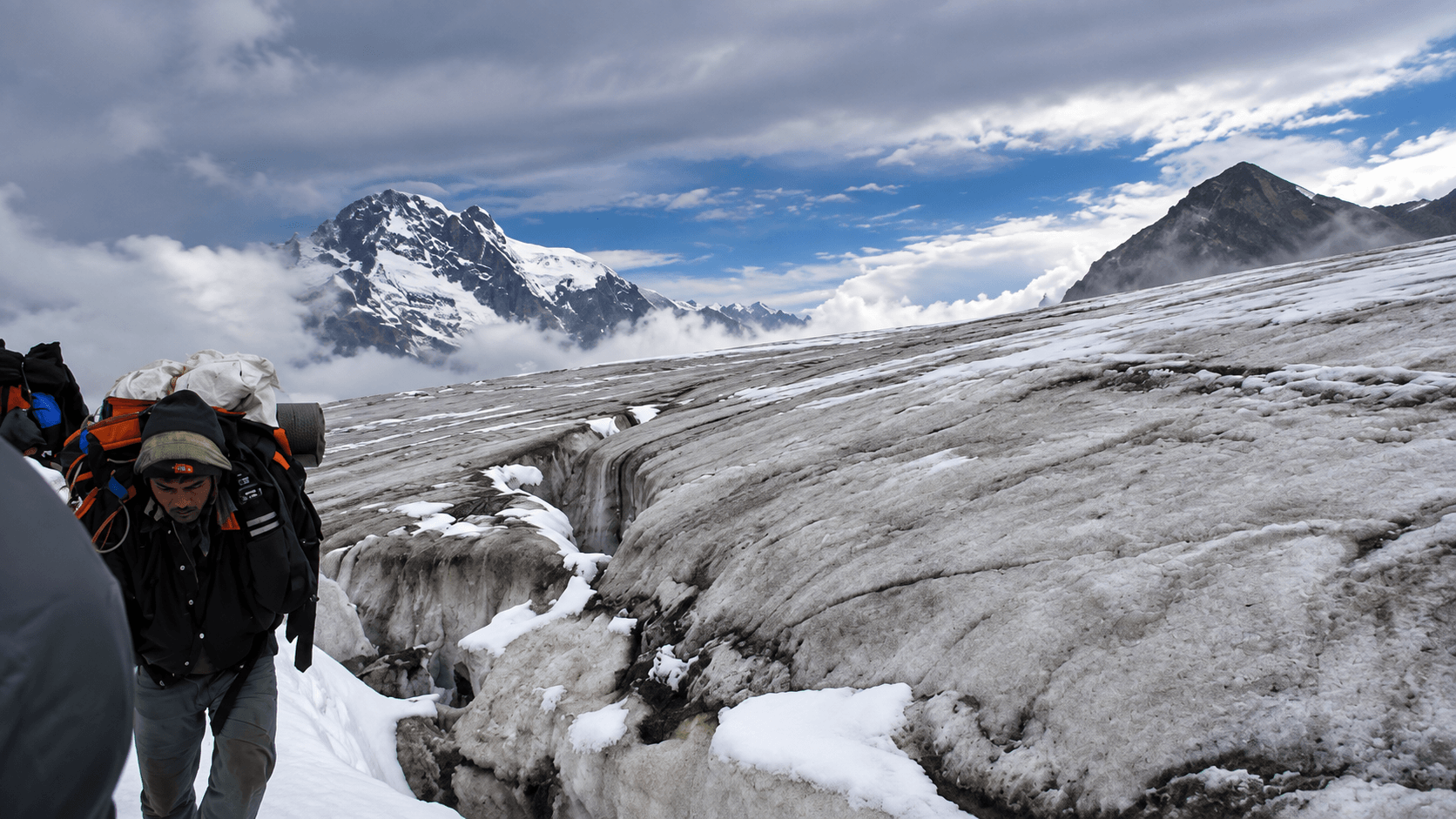
Pin Parvati Pass (5,319 m) is graded T4+/T5 on the SAC Alpine scale, classed as a Very Strenuous and Expedition-level Himalayan traverse due to its complex glaciation, unstable snow bridges, crevasse exposure, and highly unpredictable weather. Unlike most high passes, it combines humid forest approaches and deep bogs with a sudden transition to a vast crevassed ice field, demanding rope discipline, crampons, and confident glacier judgment even though no technical climbing is involved. The crossing includes multiple swift, frigid river systems, monsoon-affected slush zones, and a terrain mix so diverse that acclimatization, stamina, and real-time decision-making become as crucial as gear. With minimal retreat options once committed to the Parvati Glacier, Pin Parvati stands among India’s most objectively hazardous treks, where mountaineering caution is compulsory despite a trekking classification.
ITINERARY
The true appeal of the Pin Parvati trek lies in its remarkable transition between two contrasting Himalayan worlds. Beginning amidst dense forests of pine, deodar, and birch, cascading waterfalls, alpine meadows, and glacial valleys of the Parvati region, the route gradually ascends to the formidable Pin Parvati Pass, before descending into the stark beauty of Spiti, one of the highest inhabited cold deserts on Earth. The trek is celebrated not only for its physical challenge—with glaciers, river crossings, moraines, and high-altitude terrain, but also for the rare opportunity to experience two distinct ecosystems, cultures, and landscapes within a single journey.
On your arrival at Delhi international airport, our office staff, most likely your trekking manager will come to receive you and assist you in smooth check in to a centrally located hotel. From here you will find easy to explore Delhi and reach the next morning departure point, either the New Delhi railway station or the domestic airport, as per the demand of your tour program.
Hotel/ Camp- Oberoi Maidens
Meal Plan - Room + Breakfast + welcome dinner
After an early breakfast, transfer to the domestic terminal of Delhi Airport to board a scenic one-hour flight to Kullu, nestled in the heart of the Himalaya. Upon arrival at Kullu Airport, our representative will welcome you and assist with the short drive to Manali, a charming mountain town situated on the banks of the Beas River. The two-hour journey winds through picturesque valleys, apple orchards, traditional Himachali villages, and dense forests of pine and deodar, offering a delightful introduction to the landscapes of Himachal Pradesh.
On reaching Manali, check in to your hotel and enjoy the remainder of the day at leisure to relax and acclimatise to the mountain environment. Depending on your arrival time, you may take a leisurely walk along the vibrant Mall Road, visit nearby cafés, or simply unwind amidst the serene Himalayan surroundings in preparation for the trekking adventure ahead.
Hotel/ Camp- Eco Groves
Meal Plan - Room + Breakfast
The day begins with an acclimatisation hike to Arjun Gufa (Arjun Cave), the trail to which starts just above Hotel Eco Groves. This pleasant three-hour round-trip walk serves as an ideal introduction to the Himalaya before the trek to Parang La. Besides helping your body gradually adapt to the higher altitude, the trail rewards you with magnificent panoramic views of the entire Manali Valley, the Beas River, and the surrounding snow-clad peaks. According to local legend, the cave is associated with Arjuna of the Mahabharata, who is believed to have meditated here during his quest for divine weapons.
After returning to the hotel, enjoy lunch and spend the afternoon making the final preparations for the expedition. You will sort and pack your trekking equipment, followed by a comprehensive briefing with your trekking guide and kitchen team, who will explain the route, safety procedures, camping arrangements, and other logistical details. This is also an opportunity to clarify any questions before setting out into the remote Himalaya.
In the evening, take a leisurely stroll along Manali's vibrant Mall Road, where you can browse local handicrafts, enjoy the lively atmosphere, or simply relax before returning to the hotel for dinner and a restful night in preparation for the adventure ahead.
Hotel/ Camp- Eco Groves
Meal Plan - Room + Breakfast
Manali – Manikaran – Barshaini drive | 85 km |4 Hours – Pulga walk (2,350 m) – 2 km | 30–45 Minutes
After a leisurely breakfast, depart from Manali and drive through the picturesque Kullu Valley towards the enchanting Parvati Valley, one of the most scenic valleys in the western Himalaya. Following the course of the Beas River before entering the narrow Parvati Gorge, the route passes through apple orchards, traditional Himachali villages, and dense forests of pine and deodar. En route, stop at the sacred town of Manikaran (1,760 m), renowned for its natural hot sulphur springs and the historic Gurudwara Shri Manikaran Sahib, one of the holiest pilgrimage sites in Sikhism. Revered by both Sikhs and Hindus, Manikaran is associated with numerous legends and has been an important centre of pilgrimage for centuries. Visitors may also witness the fascinating tradition of preparing food using the naturally boiling hot springs.
Continuing upstream along the Parvati River, reach Barshaini, the road-head and the starting point of the Pin Parvati Pass trek. From here, a short and pleasant walk-through fragrant pine forests lead to the beautiful village of Pulga (2,350 m), known for its traditional wooden houses, peaceful atmosphere, and magnificent views of the surrounding Himalayan peaks. Your campsite is set amidst lush alpine meadows and towering conifer forests, providing an ideal environment to relax and enjoy the serenity of the mountains before beginning the trekking expedition. The remainder of the day is free to settle into camp, explore the village, and make final preparations for the challenging journey across the historic Pin Parvati Pass.
Hotel/ Camp- Adventure India Camp
Meal Plan - All meals
Trek: Pulga (2,350 m) to Kheer Ganga (2,960 m) – 12 km | 5–6 Hours
After an early breakfast, begin your trek through the enchanting Parvati Valley, following well-defined forest trails that wind through dense stands of pine, deodar, oak, and rhododendron. The route ascends gradually alongside the roaring Parvati River, crossing wooden bridges and passing small seasonal cafés and shepherd shelters before entering increasingly pristine alpine forests. Throughout the day, magnificent waterfalls tumble down the steep mountainsides, while snow-clad peaks occasionally emerge through the forest canopy, offering spectacular views of the surrounding Himalayan landscape.
The final section involves a steady ascent through fragrant conifer forests to reach the idyllic meadow of Kheerganga (2,960 m), one of the most celebrated trekking destinations in Himachal Pradesh. Steeped in mythology, Kheerganga is revered in Hindu tradition as the meditation site of Lord Shiva, while local legends also associate the region with Guru Nanak Dev Ji, the founder of Sikhism, whose visit to the Parvati Valley is commemorated in the nearby pilgrimage centre of Manikaran. The area is famous for its natural hot sulphur springs, where trekkers can enjoy a relaxing bath while surrounded by magnificent Himalayan scenery—an ideal reward after the day's walk.
Spend the evening at the campsite, soaking in the tranquil mountain atmosphere and preparing for the increasingly remote and demanding stages of the Pin Parvati Pass expedition.
Hotel/ Camp- Adventure India Camp
Meal Plan - All meals
Trek: Kheerganga (2,960 m) to Tunda Bhuj (3,285 m) – 11 km | 6–7 Hours
After breakfast, continue your journey deeper into the pristine Parvati Valley as the trail gradually leaves behind the popular trekking route to Kheerganga and enters the remote wilderness leading towards the Pin Parvati Pass. From this point onwards, the landscape becomes increasingly isolated, with dense forests giving way to expansive alpine meadows, glacial streams, and towering mountain ridges. Shortly after leaving Kheerganga, the trail divides into two routes; the expedition follows the traditional lower trail, which meanders through vibrant meadows carpeted with seasonal wildflowers and offers beautiful views of the Parvati River flowing through the valley below.
As the day progresses, the route passes a few seasonal encampments of the Gaddi shepherds, the traditional pastoral community of Himachal Pradesh, who migrate to these high-altitude pastures during the summer months with their flocks of sheep and goats. Beyond these grazing grounds, signs of permanent human habitation disappear, marking the beginning of a truly remote Himalayan expedition. The trail continues through a mixture of birch forests, alpine grasslands, and rocky sections before reaching the picturesque campsite of Tunda Bhuj (3,285 m), situated beside the Parvati River and surrounded by towering snow-clad peaks. The peaceful setting provides an ideal place to rest, enjoy the spectacular mountain scenery, and prepare for the higher elevations that lie ahead.
Hotel/ Camp- Adventure India Camp
Meal Plan – All meals
Trek: Tunda Bhuj (3,285 m) to Thakur Kuan (3,560 m) – 8 km | 4–5 Hours
After breakfast, continue trekking upstream through the increasingly rugged upper reaches of the Parvati Valley. The trail follows the left bank of the Parvati River, traversing rocky terrain, glacial debris, and patches of dense birch and juniper vegetation. As the valley narrows, the scenery becomes increasingly dramatic, with towering granite cliffs, cascading waterfalls, and snow-covered peaks dominating the landscape. The route is relatively short but involves negotiating boulder fields and uneven sections, requiring careful footing throughout the day.
The destination is Thakur Kuan (3,560 m), a beautiful alpine campsite situated on grassy meadows beside the Parvati River. In the local dialect, Kuan means "well" or "spring," a reference to the natural water sources found in the area that have long served shepherds and travellers crossing these mountains. Surrounded by magnificent Himalayan scenery, the campsite offers excellent opportunities to relax, photograph the spectacular valley, and continue acclimatising before entering the higher glacial region of the Pin Parvati Pass. The peaceful setting and pristine wilderness make Thakur Kuan one of the most memorable campsites along the expedition.
Hotel/ Camp- Adventure India Camp
Meal Plan – All meals
Trek: Thakur Kuan (3,560 m) to Mantalai Lake (4,100 m) – 12 km | 6–7 Hours
Today's trek takes you into the upper reaches of the Parvati Valley, where the landscape becomes increasingly wild and glaciated. After breakfast, follow the Parvati River across rocky terrain and alpine meadows before reaching the famous Pandu Bridge, a remarkable natural rock bridge spanning the river. According to local folklore, the bridge is associated with the Pandavas of the Mahabharata, who are believed to have crossed this region during their final journey towards the Himalaya. After crossing the bridge, the trail undulates through expansive flower-filled meadows, glacial streams, and moraines, with magnificent views of the surrounding snow-clad peaks.
The final approach to Mantalai Lake (4,100 m) involves a steep ascent of approximately 200 metres over boulder-strewn terrain. Although the climb is physically demanding, particularly for first-time trekkers, it is well within the capabilities of anyone with reasonable fitness and is an excellent introduction to high-altitude mountain travel. Nestled beneath towering glaciers, Mantalai Lake is revered in Hindu mythology as the legendary birthplace of the Parvati River and is believed to be the sacred place where Lord Shiva and Goddess Parvati are said to have spent time together after their divine marriage. Surrounded by pristine alpine wilderness and dramatic Himalayan peaks, the lake offers one of the most serene and spiritually significant settings of the expedition. After approximately 6–7 hours of trekking, arrive at the campsite beside the lake and enjoy the tranquillity of this spectacular high-altitude environment while preparing for the challenging ascent to the Pin Parvati Pass in the days ahead.
Hotel/ Camp- Adventure India Camp
Meal Plan – All meals
Trek: Mantalai Lake (4,100 m) to High Camp (4,700 m) – 10 km | 6–7 Hours
Today marks the beginning of the expedition's most demanding phase as you leave the lush upper meadows of the Parvati Valley and enter the rugged glacial terrain leading to the Pin Parvati Pass. After an early breakfast, the trail gradually ascends through a dramatic landscape of moraines, loose scree, boulder fields, and glacial streams. Vegetation soon disappears, giving way to an austere world of rock, ice, and snow where towering peaks and hanging glaciers dominate the skyline. As the altitude increases, the terrain becomes progressively more challenging, requiring careful footing and a steady pace.
This section of the trek offers a genuine taste of Himalayan expedition travel. Even experienced mountaineers must navigate the constantly changing glacial landscape with caution, as snow cover, moraine formations, and stream crossings can alter the route from season to season. Under the guidance of your experienced trek leader, you will learn the importance of route selection, safe movement across unstable terrain, and maintaining a consistent rhythm at high altitude—valuable skills for anyone aspiring to undertake more demanding Himalayan expeditions.
After approximately 6–7 hours of trekking, arrive at High Camp (4,700 m), the final campsite before the ascent to Pin Parvati Pass. Nestled amidst glaciers and rugged mountain slopes, the camp provides spectacular views of the surrounding peaks and an unforgettable wilderness experience. Spend the remainder of the day resting, hydrating well, and preparing both physically and mentally for the challenging crossing of the pass on the following day.
Hotel/ Camp- Adventure India Camp
Meal Plan – All meals
Trek: Pin Parvati Base Camp (West) (4,750 m) – Pin Parvati Pass (5,319 m) – Odi Thach (3,850 m) | 14 km | 7–9 Hours
Today is the most challenging and rewarding day of the expedition as you cross the legendary Pin Parvati Pass (5,319 m), the spectacular gateway linking the lush Parvati Valley of Kullu with the stark cold desert of Spiti. An early pre-dawn start is essential to take advantage of stable snow conditions and favourable weather. From the campsite, the trail ascends steeply for nearly 600 metres over glacial moraine, snowfields, and loose rock before reaching the final approach to the pass. Depending on seasonal snow conditions, the expedition team may use crampons, ropes, or ice axes to negotiate certain sections safely. The steady climb demands endurance and determination, but every step brings you closer to one of the most celebrated mountain crossings in the Indian Himalaya.
The summit of Pin Parvati Pass is marked by colourful prayer flags and traditional stone cairns, symbolising the centuries-old connection between the Hindu culture of Kullu and the Buddhist communities of Spiti. From the top, breathtaking views extend across the glaciers and verdant valleys of Parvati on one side and the rugged, barren mountains of Pin Valley on the other, offering a striking contrast between two distinct Himalayan landscapes. After spending time at the pass, begin the long descent across snowfields, glacial streams, and rocky moraines into the upper Pin Valley. The terrain gradually becomes less steep as you arrive at Odi Thach (East Base Camp) (3,850 m), a beautiful alpine campsite surrounded by vast meadows and dramatic mountain scenery. Having successfully crossed one of India's most demanding trekking passes, enjoy a well-earned rest while reflecting on a truly unforgettable Himalayan achievement.
Hotel/ Camp- Adventure India Camp
Meal Plan – All meals
Trek: Odi Thach (3,850 m) to Mud Village (3,810 m) – 16 km | 6–7 Hours
After breakfast, continue your descent through the spectacular Pin Valley, one of the most pristine landscapes in the Trans-Himalaya and a part of the renowned Pin Valley National Park. The trail follows the Pin River through expansive alpine meadows, colourful sedimentary mountains, and dramatic rock formations that change hues throughout the day—from shades of ochre and gold in the morning to deep crimson and purple under the evening sun. This constantly changing palette of colours is one of the defining characteristics of Spiti's cold desert landscape and offers exceptional opportunities for photography.
By afternoon, arrive at the picturesque village of Mud (3,810 m), the last permanently inhabited settlement in the Pin Valley and the traditional gateway for trekkers crossing the Pin Parvati Pass and the Bhaba Pass. This charming Himalayan hamlet, with its whitewashed mud-brick houses, prayer flags, and fertile barley fields, offers a striking contrast to the rugged wilderness traversed over the previous days. Mud has gradually evolved into a welcoming base for trekkers, with a number of family-run guesthouses, cafés, and small eateries serving simple but hearty local cuisine. It also marks the starting point of the historic trekking route to the Bhaba Pass, which connects the Pin Valley with the lush forests and apple orchards of the Kinnaur region. Spend the evening relaxing amidst the peaceful surroundings and experiencing the warm hospitality of the people of Spiti after successfully completing one of the Himalaya's most challenging trans-mountain crossings.
Hotel/ Camp- Tara Guest House
Meal Plan – All meals
Drive: Kungri Monastery and Tabo – 42 km | 2 Hours
After breakfast, enjoy the drive down the picturesque Pin Valley towards Gulling, following a well-defined trail through fertile fields, traditional villages, and the spectacular landscapes of the Spitian cold desert. Although Mud is connected by road, trekking this section offers a far richer experience, allowing you to appreciate the valley's remarkable scenery at a leisurely pace. The trail follows the Pin River through broad valleys, crossing glacial streams and passing the charming village of Sagnam, where clusters of traditional mud-brick houses, cultivated barley fields, and fluttering prayer flags provide an authentic glimpse into everyday life in one of India's most remote Himalayan communities.
Board your waiting vehicle and drive to the historic Kungri Monastery (3,500 m), the spiritual heart of the Nyingma school of Tibetan Buddhism in Spiti. Founded nearly 900 years ago, Kungri is the second-oldest monastery in Spiti and is renowned for its ancient murals, sacred scriptures, and annual Devil Dance (Cham) festival, preserving one of the oldest continuous Buddhist traditions in the Himalaya.
After exploring the monastery, continue the scenic drive to Tabo (3,280 m), one of the most important cultural centres in the Trans-Himalaya. On arrival, check into your comfortable hotel and enjoy the remainder of the evening at leisure, surrounded by the timeless landscapes and rich Buddhist heritage of the Spiti Valley.
Hotel/ Camp- Maitreya Hotel
Meal Plan – All meals
Tabo – Dhankar – Kee Monastery – Kibber – Kaza Approximately 85 km | 5–6 Hours (excluding sightseeing)
Altitude: Tabo – 3,280 m | Dhankar – 3,894 m | Kee Monastery – 4,116 m | Kibber – 4,270 m | Kaza – 3,650 m
After breakfast, begin a fascinating journey through the cultural heart of the Spiti Valley, exploring some of the oldest and most revered Buddhist monasteries in the Indian Himalaya. Your first stop is the ancient village of Dhankar, the former capital of the Spiti Kingdom, dramatically perched on a rocky cliff overlooking the confluence of the Spiti and Pin Rivers. Visit the magnificent Dhankar Monastery, believed to have been founded over a thousand years ago, where ancient murals, Buddhist scriptures, and panoramic views of the surrounding valleys offer a glimpse into Spiti's rich spiritual heritage.
Continue northwards to Kaza, the administrative headquarters of Spiti Valley, before ascending to the iconic Kee Monastery (4,116 m), the largest and most influential monastery in the region. Perched atop a hill overlooking the Spiti River, this thousand-year-old monastery serves as an important centre of Buddhist learning and is home to a thriving community of monks. The monastery also houses the residence of the 19th reincarnation of the great translator Rinchen Zangpo, whose contributions to the spread of Buddhism throughout the western Himalaya remain unparalleled.
A short drive further brings you to the picturesque village of Kibber (4,270 m), one of the highest permanently inhabited villages in the world connected by a motorable road. Wander through its traditional stone houses, interact with the friendly local community, and enjoy breathtaking views of the surrounding Himalayan ranges and the nearby Kibber Wildlife Sanctuary, home to species such as the Himalayan ibex, blue sheep, and the elusive snow leopard. Later in the afternoon, return to Kaza, where you will check into your hotel and enjoy a well-earned evening of comfort after an inspiring day exploring the remarkable cultural and natural heritage of Spiti.
Hotel/ Camp- Sakya Abode
Meal Plan – All meals
The return programme from Spiti will be determined by the prevailing road and weather conditions, particularly the status of Kunzum Pass, which may occasionally be affected by snowfall, landslides, or maintenance work. To ensure both safety and comfort, the expedition leader will select the most appropriate route from the following two options.
Option A: Via Kinnaur (Recommended if Kunzum Pass is Closed)
Day 14: Kaza – Kalpa
Drive: Approximately 220 km | 8–9 Hours
Travel through the spectacular Spiti Valley and the Sutlej Gorge to the picturesque village of Kalpa (2,960 m) in the Kinnaur region. The journey offers magnificent views of deep river gorges, traditional Himalayan villages, and the snow-clad Kinner Kailash Range. Overnight stay at a comfortable hotel in Kalpa.
Hotel/ Camp- Kinner Villa
Meal Plan – All meals
Day 15: Kalpa – Shimla
Drive: Approximately 250 km | 8–9 Hours
Drive through the scenic Kinnaur and Shimla Hills, following the historic Hindustan–Tibet Road before arriving in Shimla, the former summer capital of British India. Overnight stay at a hotel.
Hotel/ Camp- Radisson Hotel
Meal Plan – Half Board
Day 16: Shimla Sightseeing – Chandigarh/Delhi
Enjoy a relaxed morning exploring the colonial heritage of Shimla, including The Ridge, Christ Church, and Mall Road, before driving to Chandigarh or Delhi, depending on your onward flight schedule. Overnight stay at a hotel.
Hotel/ Camp- Oberoi Maidens/ Delhi
Meal Plan – Half Board
Option B: Via Kunzum Pass and Manali (If Kunzum Pass is Open)
Day 14: Kaza – Manali
Drive: Approximately 185 km | 7–8 Hours
Drive across the spectacular Kunzum Pass (4,551 m), descend through the Lahaul Valley, pass Atal Tunnel, and arrive in the beautiful hill town of Manali (2,050 m). Overnight stay at a hotel.
Day 15: Manali – Chandigarh
Drive: Approximately 300 km | 8–9 Hours
Follow the scenic Beas Valley through Kullu, Mandi, and Bilaspur before reaching Chandigarh. Overnight stay at a hotel.
Day 16: Chandigarh – Delhi Sightseeing
Drive to Delhi and, depending on your international flight schedule, enjoy a half-day sightseeing tour of the capital city or simply relax at your hotel. A detailed programme will be shared in advance according to your departure plans.
Day 17: International Departure
At the appropriate time, transfer to Indira Gandhi International Airport, Delhi, to board your onward flight home.
Unified Difficulty Matrix (Global Standards Aligned)
For Pin Parvati Pass: Kullu → Pin Valley, Spiti
| Dimension | SAC T-Scale | Nepal Trek Grade | Indian Trek Grade | UIAA Overlap Zone | Pin Parvati Position |
| Technical Terrain | T4+ to T5 (Demanding Alpine) | Very Strenuous | Very Difficult / Expedition Trek | UIAA I–II (glacier approach + crevasse caution) | T4+/T5 (season-dependent) |
| Altitude | 5,000–5,319 m | Extreme altitude zone | High & continuous | Not UIAA graded | Long stay above 4,800 m |
| Glaciation | Continuous snowfields, crevasse-prone sections | High glacier complexity | Requires crampons, rope recommended | UIAA glacier domain | Crevasses + snow bridges |
| Terrain Mix | Forest, boulder maze, marsh, moraine, glacier, ice shelves | Highly demanding mix | Full-spectrum terrain challenge | — | One of India’s most varied and punishing |
| River Crossings | Multiple, cold, swift, risky | Very high cold water hazard | Rope-assisted recommended | Not UIAA graded | Key difficulty factor |
| Weather Exposure | Snowstorms, whiteouts, monsoon saturation | Severe | Severe & unpredictable | Alpine seriousness II–III | High, especially on glacier top |
| Remoteness | High, but exits possible early stage | Remote | Evacuation difficult post-glacier | — | No retreat after Parvati glacier entry |
| Risk Factors | Crevasses, snow bridges, rockfall, river surge | AMS + hypothermia risk | Highest Himalayan trek hazard mix | Alpine seriousness III | Objectively hazardous |
| Endurance Load | Long days + altitude + soft snow drag | Extreme fatigue | Expedition-level stamina | — | 12–14 hr summit day possible |
| Skill Requirement | Confident alpine trekker with glacier sense | Experienced | Requires rope, crampons, river protocol | UIAA beginner–intermediate | Serious glacier judgement required |
Frequently Asked Questions
Cost: N/A USD
Adventure India operates a conservation initiative in the Himalaya, focusing on environmental awareness among high-altitude village youth and women. These communities live in the most ecologically sensitive zones, where daily life depends directly on fragile natural resources, such as glaciers, forests, water sources, grazing lands, and weather cycles. By beginning education and advocacy within these settlements, we aim to strengthen local stewardship and create long-term guardianship of mountain ecosystems.
You are welcome to contribute to this programme either through financial support or by offering your time and expertise. If your schedule allows, you may also join us as a resource person in one of our forthcoming workshops, training sessions, or field-based conservation activities.
Click here for more information
PROJECT CAUSE INITIATIVE
Project Cause is a dedicated health-awareness initiative launched in 2024, following the fourth-stage breast cancer diagnosis of one of our core team members, a seasoned mountain traveller with extensive Himalayan trekking experience, including Everest Base Camp and multiple high-altitude rescue operations on the frozen Zanskar River. After confronting the disease with remarkable strength and ultimately overcoming it, she committed herself to creating awareness, encouraging early detection, and offering counselling to women across the Himalayan belt, from Ladakh to Arunachal Pradesh.
Adventure India is honoured to collaborate in this mission. Together, we organise medical outreach camps in remote mountain settlements, where she and specialised oncologists from one of India’s leading cancer institutes provide screening, consultations, education, and emotional support to local women. In many of these regions, conversations around breast cancer remain socially restricted or dismissed, making this intervention not only medical but deeply transformational.
Your contribution, whether financial or voluntary, will directly support Himalayan women living in some of the world’s most inaccessible terrains, where healthcare access is minimal and the stigma around cancer remains strong. By donating to Project Cause, you help ensure early testing, informed dialogue, and dignified support for a population often left unseen in the wider healthcare discourse.
Click here for more information
Terms and Conditions
1. Eligibility: Fitness, Experience & Motivation
All participants must be physically fit, technically prepared, and mentally motivated for high-altitude climbing. Your mountaineering résumé and experience records will be reviewed before we submit the team application to the Indian Mountaineering Foundation (IMF).
While peaks above 7,000 m demand exceptional stamina and technical competence, numerous Himalayan summits below 6,000 m are equally challenging due to route complexity, weather exposure, remoteness, and objective hazards.
2. Delayed Departure & Early Closure
Expedition timelines may shift due to weather, route conditions, medical concerns, permit directives, or the leader’s safety decisions.
- Delayed closure: Any extension of the itinerary will incur additional charges.
- Early pack-up/retreat: Should the expedition conclude earlier than scheduled, no refund will be provided.
- Any extra transport, hotel stay, lodge/camp nights, or logistical support arising out of delays, roadblocks, medical evacuation, or administrative regulation will be billed separately on a cost-to-cost basis.
3. Satellite Phones, Filming & Drone Permissions
Satellite communication devices are subject to regional security restrictions and cannot be used freely across the Himalaya.
- Only company-registered satellite phones may be used, and will be provided on additional rental in the areas allowed by the Indian Government.
- Drone operations, documentary filming, and aerial recording require prior permits, which vary by district, border zone, and wildlife protection area.
All protocols must be strictly followed to avoid administrative intervention or penalties.
4. Refund Policy
All refund considerations will follow the official cancellation policy issued along with your expedition dossier. Refunds, where applicable, will be processed only as per those terms.
5. Health, Insurance, Rescue & Indemnity
Participants must hold valid high-altitude insurance, including evacuation coverage.
- Any emergency medical service, evacuation helicopter, ground rescue, insurance activation, or hospitalisation can be coordinated through us in the knowledge of LO, but must be paid directly by the team or the insurer.
- All members are required to sign an Indemnity & Risk Acceptance Bond with Adventure India before departure.
6. Booking Confirmation
Once all expedition details, services, and logistics are finalised, the following payment schedule applies:
- 50 % of the expedition fee + IMF fee at the time of confirmation
- Remaining balance payable 61 days before expedition commencement
- 100% advance payment is required for last-minute bookings (booking within 61 days before departure)
7. Non-Refundable / Non-Credit Services
Expedition pricing is quoted as a complete logistical package, not as itemised services.
Therefore, no partial refunds, credits, or adjustments will be issued for unused services (e.g., unused load-ferry, camp nights, high-altitude rations, guide days, transport segments, etc.).
We strongly recommend purchasing full travel cancellation insurance at the time of booking.
8. Replacement Participant
If you nominate another climber to take your place:
- All cancellation charges will be fully waived provided:
- The replacement climber meets the fitness and mountaineering requirements, and
- Secures IMF approval and permit to climb the peak.
9. Sightseeing & Post-Expedition Extensions
Following intense climbing periods in remote high-altitude environments, we encourage participants to decompress and experience India’s cultural and natural richness.
Extension trips may be arranged at additional cost to:
- Taj Mahal / Agra
- Rajasthan Desert & Fort Circuit
- Ladakh & Trans-Himalaya Culture
- Goa / Konkan Coast
- South India (Kerala, Tamil Nadu, Karnataka)
- Northeast India or custom destinations
Cancellation policy
| Cancellations made more than 60 days before departure | A cancellation fee of 10% of the total trip cost will be charged, and the remaining amount will be refunded. |
| Cancellations made between 45 and 60 days before departure | A cancellation fee of 25% of the total trip cost will be charged, and the remaining amount will be refunded. |
| Cancellations made between 30 and 45 days before departure | A cancellation fee of 50% of the total trip cost will be charged, and the remaining amount will be refunded. |
| Cancellations made less than 30 days before departure | The entire deposit will be forfeited. |
UIAA Grade and UIAA Declaration
Shivling’s normal West Ridge climbs at UIAA IV–V (with V+ sections), Alpine grade D, and WI 3–4 ice, while its harder North Face and pillar lines rise to UIAA VI–VII (sometimes VII+), Alpine D+ to ED, and WI 4–5 / M5–M6+, confirming it as a serious granite-ice pyramid peak and comparable in commitment to Alpamayo, Ama Dablam, and Khan Tengri.